Sugarloaf Fire Tower
US 186, AR 5
Lookout Details
| Registry Numbers | US 186, AR 5 (view other lookouts in United States, Arkansas) |
| Date Registered | August 20, 1996 |
| Nominated by | Michael A. Pfeiffer, FFLA |
| Location |
Ozark National Forest Stone County, Arkansas |
| Coordinates |
N 36° 05.017' W 092° 09.866' (view using Google Maps) N 36° 05' 01" W 092° 09' 52" N 36.083620° W 092.164432° |
| Elevation | 1,089 ft (332 m) |
| Administered by | U.S. Forest Service |
| Cooperators | Sylamore Ranger District |
Description
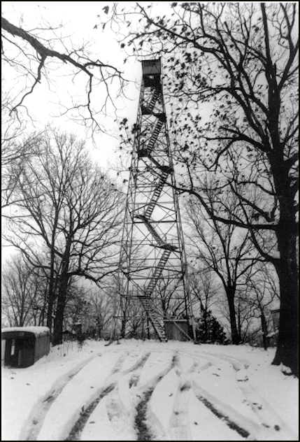
The Sugarloaf Fire Tower historic district was accepted on the National Register of Historic Places in October, 1995. The mountaintop, located on the Ozark National Forest, is the site of a remarkable group of stone structures constructed by the CCC in 1937 as living accommodations for the 100’ steel lookout tower with 7’x7’ cab.
Map
Change Basemap
Visit Reports
March 15, 2023: Anthony Smith
Condition |
|
| Needs paint? | Yes |
| Shutters OK? | No |
| Condition of wood OK? | Yes |
| Stairs OK? | Yes |
| Glass intact? | No |
| Good condition? | Yes |
| Comments: | A locked gate blocks the mile-ish long gravel road to get to the tower. A path is visible where trucks have been able to drive around it, but if you're driving a low car or a non 4x4 expect to walk all the way up, as I ended up having to do. There is a ~500 foot elevation gain from this gate to the tower. Stairs are very solid, mild graffiti scratched into metal, no glass, and antennas that I assumed to be radio equipment are attached to the outside of the cab. There's a very old stone house next to the tower that was previously boarded up, but has been broken into at some point. There is also an old outhouse and a separate, small cement bunker like structure dug into the ground that I thought may have been used for storage at some point. |
Electronics and Enroachments |
|
| Are electronic sites enroaching on tower? | Yes |
| Comments: | Yes, antennas. |
Access and Signs |
|
| NHLR sign posted? | No |
| Directions to tower signed? | No |
| Comments? | Locked gate to drive up to the tower |
Staffing |
|
| Staffed? | No |
Opportunities for Volunteer Support |
|
| Volunteers staffing opportunities? | Unsure |
| Volunteer maintenance opportunities? | Unsure |
October 25, 2012: Ruby Freeman
Condition |
|
| Needs paint? | Yes |
| Shutters OK? | No Response |
| Condition of wood OK? | Yes |
| Stairs OK? | No Response |
| Glass intact? | No Response |
| Good condition? | No Response |
| Comments: | Locked radio room seems to still be active, other buildings boarded up and first set of stairs has been removed. |
Electronics and Enroachments |
|
| Are electronic sites enroaching on tower? | No |
| Other enroachments? | unknown |
Access and Signs |
|
| NHLR sign posted? | Yes |
| Directions to tower signed? | No |
Staffing |
|
| Staffed? | No |
Opportunities for Volunteer Support |
|
| Volunteers staffing opportunities? | No Response |
| Volunteer maintenance opportunities? | No Response |