Webb Peak Lookout
US 451, AZ 44
Lookout Details
| Registry Numbers | US 451, AZ 44 (view other lookouts in United States, Arizona) |
| Date Registered | January 31, 2003 |
| Nominated by | Dave Lorenz, AZ/NM Registrar |
| Location |
Coronado National Forest Graham County, Arizona |
| Coordinates |
N 32° 42.656' W 109° 55.386' (view using Google Maps) N 32° 42' 39" W 109° 55' 23" N 32.710930° W 109.923100° |
| Elevation | 9,984 ft (3,043 m) |
| Administered by | U.S. Forest Service |
| Cooperators | Safford Ranger District |
Description
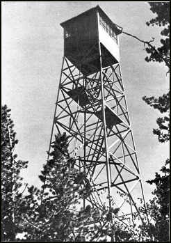
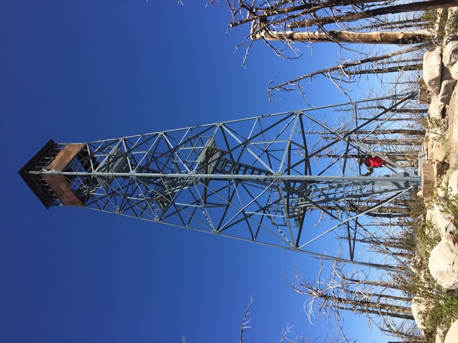
Now in inactive status, Webb Peak Lookout was constructed on the Coronado National Forest in 1933 and is listed on the National Register of Historic Places. The 46’ Aermotor MC-40 with 7’x7’ metal cab originally had a platform ladder access with handrails but has been converted and only the last section uses a ladder.
Map
Change Basemap
Visit Reports
May 13, 2020: Gary Huckleberry
Condition |
|
| Needs paint? | Not Applicable |
| Shutters OK? | Not Applicable |
| Condition of wood OK? | Not Applicable |
| Stairs OK? | Yes |
| Glass intact? | No |
| Good condition? | No |
| Comments: | This lookout was cooked by the 2017 Frye Fire. It is surrounded by charred standing and fallen timber. Temperatures on the tower exceeded 1200 F as indicated by drops of molten aluminum at the base of the structure. The steel frame of the lookout is in good condition; uncertain about the cabin at top. |
Electronics and Enroachments |
|
| Are electronic sites enroaching on tower? | No |
Access and Signs |
|
| NHLR sign posted? | No |
| Directions to tower signed? | Yes |
| Comments? | Trail head sign at Columbine Campground. However, trail to the structure is difficult to follow in places due to fallen timber and erosion. Trail connecting the lookout from Ash Creek is extremely difficult to follow due to fallen timber, aspen regrowth, and erosion. |
Staffing |
|
| Staffed? | No |
Opportunities for Volunteer Support |
|
| Volunteers staffing opportunities? | Unsure |
| Volunteer maintenance opportunities? | Unsure |
Photos |
|
|
|