Babbit Peak Lookout
US 515, CA 53
Lookout Details
| Registry Numbers | US 515, CA 53 (view other lookouts in United States, California) |
| Date Registered | May 29, 2003 |
| Nominated by | Mark Swift |
| Location |
Tahoe National Forest Sierra County, California |
| Coordinates |
N 39° 36.144' W 120° 06.446' (view using Google Maps) N 39° 36' 09" W 120° 06' 27" N 39.602400° W 120.107430° |
| Elevation | 8,727 ft (2,660 m) |
| Administered by | U.S. Forest Service |
| Cooperators | Sierraville Ranger District |
Description
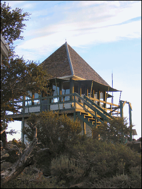
One of the classic “Dunce Cap” lookout cabs, Babbit Peak Lookout on the Tahoe National Forest is a prime example of a California region design with a steep roof pitch developed in 1923 and copied by other Forest Service regions throughout the U.S. although very few examples remain. In Oregon the design is known as the “Supervisor Hall Special.” Most of the D-5 cabs had a lower roof pitch. In good condition, the station is an active detection site.
Map
Change Basemap
Photos
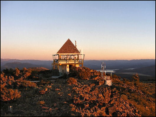
Additional photo taken in 2007, courtesy of Scott Biddle:
Visit Reports
October 22, 2011: Jack Piccinini
Condition |
|
| Needs paint? | No Response |
| Shutters OK? | Yes |
| Condition of wood OK? | Yes |
| Stairs OK? | Yes |
| Glass intact? | Yes |
| Good condition? | Yes |
| Comments: | This is a staffed lookout in good condition |
Electronics and Enroachments |
|
| Are electronic sites enroaching on tower? | No |
| Comments: | This is a great lookout to visit. It has great views of the Northern Sierra Mountains, Truckee Valley, Sierra Valley, and the Nevada mountains. You can quickly and easily spot other lookouts in the area; Sardine, Cal Pine, Sierra Buttes, Verdi, Mills, Smith and Dixie Peak to mention a few. Mount Lassen was also very visible. |
Access and Signs |
|
| NHLR sign posted? | No |
| Directions to tower signed? | Yes |
| Comments? | Three different routes to get to the final six mile leg to the top. From Loyalton, ten miles south on CR-S860 10 miles to the to the Babbit Rd (16 miles total); From Truckee, 10 miles North on Hwy 89 to the Henness Pass Road (east) AKA CR S460. Go East 10 miles to the Babbit Rd (16 Miles from Hwy 89 to tower); From Hwy 80 just east of Truckee. Take the Hirchdale exit and go North to Lake Stampeed until it hits CR S460 (20 miles total from Hwy 80). All 2 wheel drive – medium clearance vehicle will get you there. One note, there is a gate about a half mile form the tower. If it’s closed, you have to park about three quarters of a mile away from the tower . Not a difficult walk if that’s what you have to do. |
Staffing |
|
| Staffed? | Yes |
Opportunities for Volunteer Support |
|
| Volunteers staffing opportunities? | No Response |
| Volunteer maintenance opportunities? | No Response |