Bully Choop Lookout
US 300, CA 29
Lookout Details
| Registry Numbers | US 300, CA 29 (view other lookouts in United States, California) |
| Date Registered | April 21, 1999 |
| Location | Shasta County, California |
| Coordinates |
N 40° 33.297' W 122° 46.033' (view using Google Maps) N 40° 33' 18" W 122° 46' 02" N 40.554955° W 122.767221° |
| Elevation | 6,907 ft (2,105 m) |
| Built | 1978 |
| Administered by | California Dept. of Forestry |
| Cooperators | California Dept. of Forestry & Fire Protection |
Description
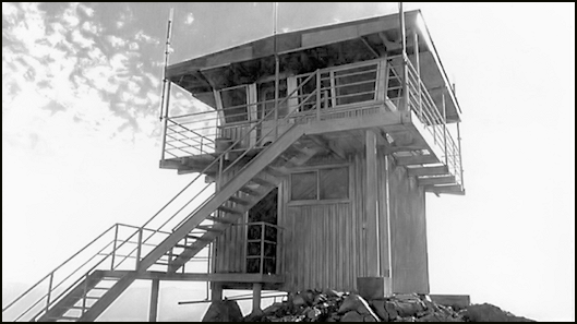
Located on the western edge of the Whiskeytown National Recreation Area in northern California, Bully Choop Lookout takes its name from the Indian phrase “Bo-li Chu-ip,” which means “high sharp peak.” Built by the California Dept. of Forestry and Fire Control in 1978, it replaced an earlier lookout dating from the 1930s. It is the first on the Register of a unique and durable CDF design. The 14 x 14’ live-in cab has slanted windows. The slightly gable roof extends over the catwalk for a permanent overhang/shade. The tower is 10’ steel I-beams covered with corrugated steel. Still in active service, the lookout is open to the public via a 14-mile road.
Map
Change Basemap