Cahto Peak Lookout
US 1125, CA 110
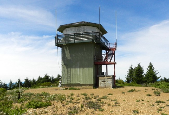
Bill Ulmer photo
Lookout Details
| Registry Numbers | US 1125, CA 110 (view other lookouts in United States, California) |
| Date Registered | March 20, 2016 |
| Nominated by | Bill Ulmer |
| Location |
Mendocino National Forest Mendocino County, California |
| Coordinates |
N 39° 41.156' W 123° 34.923' (view using Google Maps) N 39° 41' 09" W 123° 34' 55" N 39.685927° W 123.582044° |
| Elevation | 4,198 ft (1,280 m) |
| Built | 1934 |
| Administered by | California Department of Forestry and Fire Protection |
Description
Cahto Peak Lookout was dedicated July 10, 1934, following construction of a road to the summit of Cahto (Signal) Peak by the U.S. Forest Service. The site is one of the highest points in Mendocino County and is easily visible from 35 miles away. The lookout has not been staffed since 1990 due to budget cuts.
Map
Change Basemap
Visit Reports
March 17, 2019: Jordan
Condition |
|
| Needs paint? | Yes |
| Shutters OK? | No |
| Condition of wood OK? | No |
| Stairs OK? | Yes |
| Glass intact? | Yes |
| Good condition? | Yes |
| Comments: | Railings are weathered and could use repainting, decking surrounding lookout cab is deteriorating and broken in a couple places. One shutter is partially detached. |
Electronics and Enroachments |
|
| Are electronic sites enroaching on tower? | Yes |
| Comments: | Maybe a few weather/atmospheric sensors. Very limited. |
Access and Signs |
|
| NHLR sign posted? | No |
| Directions to tower signed? | No |
| Comments? | Access is via a BLM road. Road is gated approximately 0.5-1 mile from the lookout. There is one BLM sign which gives mileage to Cahto Peak, but does not reference the fire lookout. Road currently in good shape. |
Staffing |
|
| Staffed? | No |
Opportunities for Volunteer Support |
|
| Volunteers staffing opportunities? | Unsure |
| Volunteer maintenance opportunities? | Unsure |