Grouse Ridge Lookout
US 283, CA 17
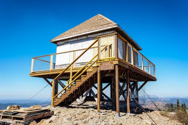
Grouse Ridge Lookout - 2016
Lookout Details
| Registry Numbers | US 283, CA 17 (view other lookouts in United States, California) |
| Date Registered | June 4, 1998 |
| Nominated by | Mark Swift |
| Location |
Tahoe National Forest Nevada County, California |
| Coordinates |
N 39° 23.149' W 120° 36.743' (view using Google Maps) N 39° 23' 09" W 120° 36' 45" N 39.385814° W 120.612375° |
| Elevation | 7,653 ft (2,333 m) |
| Built | 1923 |
| Administered by | U.S. Forest Service |
| Cooperators | Yuba River Ranger District |
Description
One of the six remaining 4AR cabs in California (see Zephyr Point), Grouse Ridge Lookout was constructed in 1923 on the Tahoe National Forest. Unusual characteristics of the 14’ x 14’ cab include a steep 12/12 pitch roof and five windows per wall. This design was a forerunner of the popular L-4 model.
Map
Change Basemap
Visit Reports
July 11, 2009: Jack Piccinini
Condition |
|
| Needs paint? | Yes |
| Shutters OK? | Yes |
| Condition of wood OK? | Yes |
| Stairs OK? | Yes |
| Glass intact? | No Response |
| Good condition? | Yes |
| Comments: | You can see where people have tried to get into it so it has some damage. Some maintenance now would be good before it gets to hard to keep it in shape. |
Electronics and Enroachments |
|
| Are electronic sites enroaching on tower? | No |
Access and Signs |
|
| NHLR sign posted? | No |
| Directions to tower signed? | Yes |
| Comments? | The site is heavily visited as it is near camp sites and day use trails. The Bowman Lake Rd off of Hwy 20 is paved so the first 6.5 miles (from the highway) is nice and easy. The second leg is five miles on the Grouse Ridge Road, which while is bumpy, is nonetheless easily traveled by 2 wheel drive. The site seems to be in use for some radio equipment, but otherwise is un-staffed. Great Views - wait until you see where the bathroom is! |
Staffing |
|
| Staffed? | No |
Opportunities for Volunteer Support |
|
| Volunteers staffing opportunities? | Yes |
| Volunteer maintenance opportunities? | Yes |