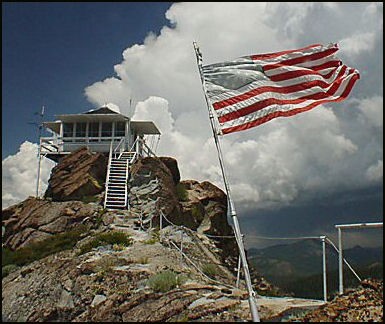
Saddleback Mountain Lookout
US 591, CA 62

Lookout Details
| Registry Numbers | US 591, CA 62 (view other lookouts in United States, California) |
| Date Registered | September 21, 2004 |
| Nominated by | Kathy Allison |
| Location |
Tahoe National Forest Sierra County, California |
| Coordinates |
N 39° 38.207' W 120° 51.861' (view using Google Maps) N 39° 38' 12" W 120° 51' 52" N 39.636780° W 120.864350° |
| Elevation | 6,625 ft (2,019 m) |
| Built | 1934 |
| Administered by | U.S. Forest Service |
| Cooperators | Downieville Ranger District |
Description
The Civilian Conservation Corps built this Forest Service architecturally designed “BC-3” live-in cab and “BETT” 7 foot tower in 1934. There is mention of asbestos tiles over the original wood siding. Saddleback Lookout is historically significant as the only “short BETT” tower on the Tahoe National Forest built by the CCC. It is a 14’x14’ BC-3 live-in groundhouse with catwalk perched on rock outcrop. It is popular with visitors.
Map
Change Basemap
Visit Reports
December 13, 2015: Tony Kelsey
Condition |
|
| Needs paint? | No Response |
| Shutters OK? | Yes |
| Condition of wood OK? | Yes |
| Stairs OK? | Yes |
| Glass intact? | Yes |
| Good condition? | Yes |
Electronics and Enroachments |
|
| Are electronic sites enroaching on tower? | No |
Access and Signs |
|
| NHLR sign posted? | No |
| Directions to tower signed? | Yes |
| Comments? | Some of the road signage has been vandalized but is presently being taken care of. |
Staffing |
|
| Staffed? |
Yes
I was the main lookout on duty during the 2015 fire season.
|
Opportunities for Volunteer Support |
|
| Volunteers staffing opportunities? | No Response |
| Volunteer maintenance opportunities? | No Response |
Other Comments |
|
| Comments | The public is welcome. Access by 4x4 recommended. Popular with public and we have many repeat visitors. |
April 23, 2010: Tom Gilfoy
Condition |
|
| Needs paint? | No Response |
| Shutters OK? | No Response |
| Condition of wood OK? | No Response |
| Stairs OK? | No Response |
| Glass intact? | No Response |
| Good condition? | No Response |
| Comments: | Comment on Saddleback Lookout: Makes a great mountain bike ride. Camped in USFS Fiddle Creek Campground on the N Fork of Yuba River and rode bike to Downieville for breakfast. From there, took the road just west of Downieville described in the prior comment to the lookout. What a view! Then took the Brandy City Road back, going by the site of the old Cal-Ida Mill and returning to Fiddle Creek in plenty of time for dinner. Great scenery all the way. |
Electronics and Enroachments |
|
| Are electronic sites enroaching on tower? | No |
Access and Signs |
|
| NHLR sign posted? | No |
| Directions to tower signed? | No |
Staffing |
|
| Staffed? | No |
Opportunities for Volunteer Support |
|
| Volunteers staffing opportunities? | No Response |
| Volunteer maintenance opportunities? | No Response |
October 17, 2009: Jack Piccinini
Condition |
|
| Needs paint? | No Response |
| Shutters OK? | Yes |
| Condition of wood OK? | Yes |
| Stairs OK? | Yes |
| Glass intact? | Yes |
| Good condition? | Yes |
| Comments: | This is a staffed lookout and is in very good condition |
Electronics and Enroachments |
|
| Are electronic sites enroaching on tower? | No |
| Comments: | Great lookout in the Tahoe NF. Great view of old surrounding lookouts such as Pilot Peak to the North, Sierra Buttes to the West, Grouse Ridge to the Southwest. I have submitted updated pictures to be posted on Google Earth. |
Access and Signs |
|
| NHLR sign posted? | No |
| Directions to tower signed? | Yes |
| Comments? | The tower is easy to get to. It is 10 miles north of Downieville CA. Just West of town is the Saddleback Road (county road 509) off of Hwy 49. It is about 10 miles of dirt road. Narrow but was easy to travel and you can make it all of the way in a two wheel drive vehicle. The last mile a bit steep and the water bars could be a problem for a very low 2X2 vehicle, but otherwise still an easy ride. Alternate route is further west of Downieville near Cal Ida. Off of Hwy 49 is Forest road 490/25. About 17 miles to the tower from that location. |
Staffing |
|
| Staffed? |
Yes
I arrived very early in the morning. I wanted to catch the sunrise behind the Sierra Buttes. The lookout was there and the tower shutters and everything open. I assume the lookout was sleeping (It was about 7 AM) so I after an hour or so without seeing anyone I left. I never made it inside the tower but that was okay - still had a great 360 degree view and was able to pick out the other area lookout towers and geo spots.
|
Opportunities for Volunteer Support |
|
| Volunteers staffing opportunities? | No Response |
| Volunteer maintenance opportunities? | No Response |