Lookout Details
| Registry Numbers | US 1019, MA 48 (view other lookouts in United States, Massachusetts) |
| Date Registered | September 3, 2014 |
| Nominated by | Henry Isenberg |
| Location |
Lenox Mountain Berkshire County, Massachusetts |
| Coordinates |
N 42° 23.583' W 073° 18.650' (view using Google Maps) N 42° 23' 35" W 073° 18' 39" N 42.393050° W 073.310833° |
| Elevation | 2,126 ft (648 m) |
| Administered by | Massachusetts Bureau of Fire Control |
Description
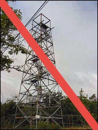
n 1915, a 48' tower was erected atop Lenox mountain and the towns of Lenox, Richmond, and Pittsfield donated $200 toward the purchase of this tower. Two miles of phone line had to be constructed to this tower. In 1952, the state bought the land under the tower and the right of way. In 1963, the tower was temporarily closed due to the poor condition of the tower and In 1966, a new 75' tower with a 10'x10' cab and new fence was built. After the new tower was built, it was dedicated and renamed in the memory of past Chief of Fire Control "Hutchinson", who at the time of his death was the oldest chief in years of service and age. In 1970, this tower blew over in a high wind storm.
In the fall of 1970, the current 68' tower was built. The tower was last staffed during the 1988 fire season. In the winter of 1995, the tower cab and stairs were destroyed by fire.
As of 2015, the tower's frame remains and is used to host communiations equipment. This tower is now listed on the Former Fire Lookout Sites page.