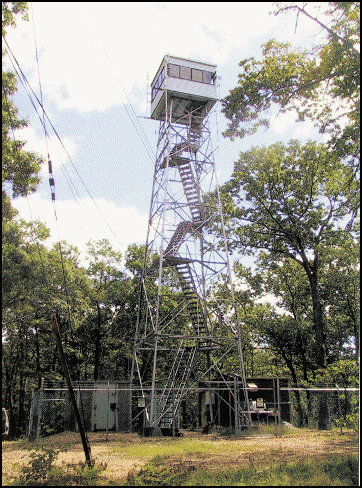
Ludlow Fire Tower
US 446, MA 4

Lookout Details
| Registry Numbers | US 446, MA 4 (view other lookouts in United States, Massachusetts) |
| Date Registered | November 13, 2002 |
| Nominated by | John Matroni, Site Manager |
| Location |
Ludlow State Forest Hampden County, Massachusetts |
| Coordinates |
N 42° 10.884' W 072° 25.837' (view using Google Maps) N 42° 10' 53" W 072° 25' 50" N 42.181400° W 072.430620° |
| Elevation | 700 ft (213 m) |
| Administered by | Mass. Bureau of Forest Fire Control |
| Cooperators | Mass. Bureau of Forest Fire Control, District 11 |
Description
Located on Minechoag Mountain just east of Springfield, Ludlow Fire Tower is easily seen from the Massachusetts Turnpike. In 1936 the 50 acre Ludlow State Forest was purchased and tower construction begun by the CCC. The original 7’x7’ metal cab on the 60’ steel tower was replaced in 1967 with the Mass. 10’x10’ aluminum cab which was upgraded again in 1999. An urban/interface tower, it is in active service.
Map
Change Basemap
Visit Reports
April 17, 2016: Jack Kelley
Condition |
|
| Needs paint? | No Response |
| Shutters OK? | Yes |
| Condition of wood OK? | Yes |
| Stairs OK? | Yes |
| Glass intact? | Yes |
| Good condition? | Yes |
| Comments: | The tower on the exterior looks good. However, it is surrounded by a chain link fence topped with barbed wire. |
Electronics and Enroachments |
|
| Are electronic sites enroaching on tower? | Yes |
| Comments: | There is a fair amount of communication equipment on the tower, and a few buildings inside a chain link fence that surround the tower site. |
Access and Signs |
|
| NHLR sign posted? | No |
| Directions to tower signed? | No |
| Comments? | Despite being within the Ludlow State Park, the tower does not appear on trail maps and is relatively isolated. |
Staffing |
|
| Staffed? |
Sometimes
Staffed seasonally.
|
Opportunities for Volunteer Support |
|
| Volunteers staffing opportunities? | No Response |
| Volunteer maintenance opportunities? | No Response |