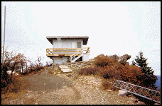
Halls Point Lookout
US 491, OR 84
Lookout Details
| Registry Numbers | US 491, OR 84 (view other lookouts in United States, Oregon) |
| Date Registered | March 31, 2003 |
| Nominated by | Howard Verschoor, Oregon Registrar |
| Location |
Rogue River National Forest Jackson County, Oregon |
| Coordinates |
N 42° 48.427' W 122° 33.320' (view using Google Maps) N 42° 48' 26" W 122° 33' 19" N 42.807120° W 122.555330° |
| Elevation | 4,470 ft (1,362 m) |
| Built | 1956 |
| Administered by | U.S. Forest Service |
| Cooperators | Prospect Ranger District |
Description
Prior to the construction of the current R-6, this point was primarily a secondary site of Whetstone Point. It was on Whetstone (in early days called Old Baldy or Bald Mountain) that the crows nest was located in a 80 foot tree in 1914. In 1920 a standard D-6 cupola was built, in 1934 the cupola was elevated onto a ten foot tower. In 1951 the State erected the 40 foot tower at the south end of the ridge (White Point). Whetstone Point being located at the mid point of the ridge was not very effective for the Forest Service to cover the northern area. The construction of Halls Point in 1956 remedied the problem and the old Whetstone Lookout was burned in 1958.
Map
Change Basemap