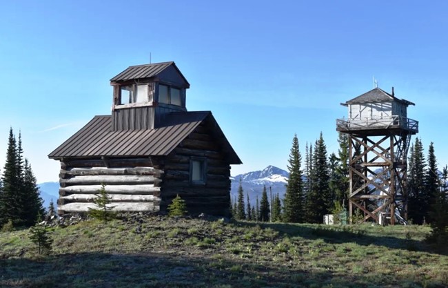
Monument 83 (Holdover Peak) Lookout - 2019
Lookout Details
| Registry Numbers | US 1552, WA 82 (view other lookouts in United States, Washington) |
| Date Registered | April 12, 2022 |
| Nominated by | Christine Estrada |
| Location |
Okanogan National Forest Okanogan County, Washington |
| Coordinates |
N 49° 00.011' W 120° 38.715' (view using Google Maps) N 49° 00' 01" W 120° 38' 43" N 49.000189° W 120.645243° |
| Elevation | 6,520 ft (1,987 m) |
| Built | 1930 and 1953 |
| Administered by | US Forest Service - Okanogan National Forest |
Description
Monument 83, also known as Holdover Peak, is located on the US-Canadian border and was first established in the 1920s as a camp with tree platform. In 1930, a log cabin cupola was constructed and celebrated as the northernmost lookout in the United States until surveys later determined it to be on Canadian soil. The cupola is now British Columbia’s southernmost lookout. In 1953 the United States built a 30′ treated timber L-4 tower on the US side of the border, reinstating Monument 83 as the northernmost lookout in both Washington State and the US. The lookouts were last used in the 1970s and both structures remain intact.
The name “Monument 83” is important for positioning the site along its place on the border, which is 83 miles from mile zero at Peace Arch Park in Surrey B.C.. From the summit it’s possible to see the United States-Canada Border Slash, a 20-foot-wide clearcut running the length of the border. Check out Atlas Obscura for some interesting trivia and tidbits about the Border Slash.
Another bonus on Monument 83 is a carved wooden gravestone bearing the inscription: “Pasayten Pete, shot by L.E. Lael, 26-8-61”. It’s been said that Pasayten Pete was a beloved pack mule.
Monument 83 was an Aircraft Warning Service site from July to September 1942.