Atascosa Lookout
US 201, AZ 8
Lookout Details
| Registry Numbers | US 201, AZ 8 (view other lookouts in United States, Arizona) |
| Date Registered | December 30, 1996 |
| Nominated by | David Lorenz, Arizona Registrar & Mary Farrell, Archaeologist, Coronado N.F. |
| Location |
Coronado National Forest Arizona |
| Coordinates |
N 31° 25.241' W 111° 08.802' (view using Google Maps) N 31° 25' 14" W 111° 08' 48" N 31.420680° W 111.146708° |
| Elevation | 6,070 ft (1,850 m) |
| Administered by | U.S. Forest Service |
| Cooperators | Nogales Ranger District & Friends of Atascosa Lookout |
Description
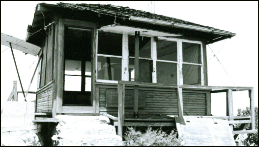
Built between 1930 and 1933, Atascosa Lookout is a 14’x 14’ groundhouse with an unusual modified hip roof with a 2’ overhang. This historic structure on the Coronado National Forest is not far from the Mexican border. It has gutters to collect rainwater for a cistern, a common-sense solution that was strangely not used often in the West. Atacosa Lookout was destroyed in the Murphy Fire on June 6, 2011.
Map
Change Basemap