Lookout Details
| Registry Numbers | US 647, CA 77 (view other lookouts in United States, California) |
| Date Registered | January 2, 2006 |
| Nominated by | Unknown |
| Location |
Six Rivers National Forest Trinity County, California |
| Coordinates |
N 40° 15.500' W 123° 15.000' (view using Google Maps) N 40° 15' 30" W 123° 15' 00" N 40.258330° W 123.250000° |
| Elevation | 6,070 ft (1,850 m) |
| Built | 1960 |
| Administered by | U.S. Forest Service |
| Cooperators | Mad River Ranger District |
Description
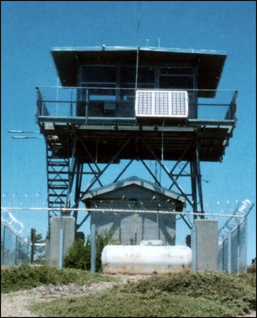
Originally constructed in 1960, Horse Ridge Lookout was moved to its present location in 1986 by a National Guard Helicopter. The CL 160 cab with catwalk on a 19’ tower is on the boundary of the Six Rivers National Forest and the Shasta-Trinity and is in active service.
Additional information courtesy of Peggy Phillips, Lookout: "...these pictures were taken in the same spot 40 years apart. Quite a change. The older tower looks taller and I was told by an old timer that he snow shoed out from the cat walk! That is a lot of snow! This tower is 19' to the bottom of the cat walk. The tower is at 6070' on Southfork Mountain, noted for being the longest continous mountain in the US. East side Is Shasta-Trinity, west is Six Rivers NF. The tower is at the highest point on Southfork Mountain and at the southern end. The lookout got its name from one of the ridges that goes down into the Mad River drainage…Horse Ridge. I was told by a local resident that their father had been on Horse Ridge and actually saw Mt Lassen to the east blow the last time it blew! What a sight that must have been. I can't remember the year but it was in the teens of the 1900's. The present tower was taken from Eight Mile at the northern end of the Mad River Distric … It was said that they almost lost it a time or two but I can attest to the fact that they installed it! I've been working in it for 6 seasons! The tower can be seen from the Mad River drainage area when the sun is in the west. It has metal covers over the windows so it glows and is a sight to see!"
Map
Photos
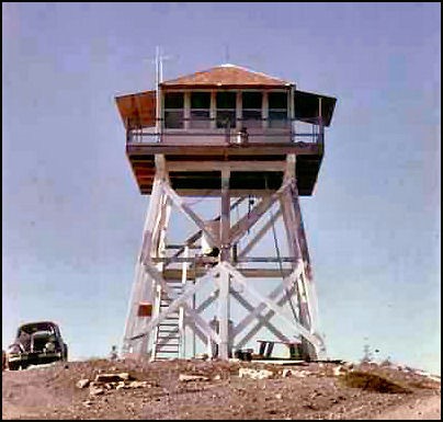
Lookout in 1966
Visit Reports
November 4, 2013: Peggy Phillips
Condition |
|
| Needs paint? | No Response |
| Shutters OK? | Yes |
| Condition of wood OK? | No Response |
| Stairs OK? | Yes |
| Glass intact? | Yes |
| Good condition? | Yes |
| Comments: | 2 story Metal Tower. Inside is pretty fair condition. Freshly painted in 2003. Experience leakage during storms from the South-west. Unable to determine location as the windows are all freshly caulked. Possibly from outside metal frames. <br /> <br />Metal structure was built on Eight Mile in Mad River District in 1960. Moved by National Guard Helicopter to Horse Ridge in June of 1986. The previous structure on Horse Ridge was built in 1933 and was destroyed in March of 1986 |
Electronics and Enroachments |
|
| Are electronic sites enroaching on tower? | No |
Access and Signs |
|
| NHLR sign posted? | No |
| Directions to tower signed? | Yes |
| Comments? | Staffed continously by full-time Forest Service personnel during fire season...usually mid June to 1st week in Nov. |
Staffing |
|
| Staffed? |
Yes
Staffed continously by full-time Forest Service personnel during fire season...usually mid June to 1st week in Nov.
|
Opportunities for Volunteer Support |
|
| Volunteers staffing opportunities? | No Response |
| Volunteer maintenance opportunities? |
No Response
Six Rivers Nat'l Forest does maintenance on what ever the Lookouts are unable to handle. Tower is on 2 National Forest boundaries, Shasta-Trinity and Six Rivers. Six Rivers' side has cleared tall timber (white fir) and has a fire line on the south and west. Shasta-Trinity has many tall trees blocking view of any possible fires and no fire line on the north and east. White Fir is only good for Christmas Trees. No market value on lumber and not good firewood. Manzanita rules on the Shasta-Trinity side.
|