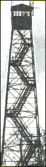
Robinson Forest Fire Tower
US 158, KY 2
Lookout Details
| Registry Numbers | US 158, KY 2 (view other lookouts in United States, Kentucky) |
| Date Registered | February 2, 1996 |
| Nominated by | Robert Muller, UK Forestry Dept. |
| Location |
Robinson Forest, Univ. of Kentucky Breathitt County, Kentucky |
| Coordinates |
N 37° 31.984' W 083° 20.797' (view using Google Maps) N 37° 31' 59" W 083° 20' 48" N 37.533070° W 083.346620° |
| Elevation | 746 ft (227 m) |
| Administered by | Department of Forestry, University of Kentucky |
| Cooperators | Department of Forestry, University of Kentucky |
Description
The woodlands of Kentucky were once covered by a network of more than 100 state towers, now there is one that remains in active service. The 100’ Aermotor Robinson Tower was built by the CCC in 1934 replacing two wooden towers and the Tip Rock observation site within the 15,000-acre Robinson Forest. It is staffed by the Department of Forestry at the University of Kentucky which owns the forest.
Map
Change Basemap