Barnstable Fire Tower
US 559, MA 9
Lookout Details
| Registry Numbers | US 559, MA 9 (view other lookouts in United States, Massachusetts) |
| Date Registered | February 2, 2004 |
| Nominated by | Henry Isenberg |
| Location |
Clay Hill Barnstable County, Massachusetts |
| Coordinates |
N 41° 41.110' W 070° 21.460' (view using Google Maps) N 41° 41' 07" W 070° 21' 28" N 41.685167° W 070.357667° |
| Elevation | 66 ft (20 m) |
| Built | 1947 |
| Administered by | Mass. Bureau of Forest Fire Control |
| Cooperators | Mass. Bureau of Forest Fire Control, District 1 |
Description
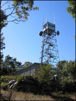
The first fire lookout in Barnstable County on Cape Cod was staffed in 1912 on a wooden tower built by donors on Shoot Flying Hill in 1897. A steel tower was built in 1912 and stood until 1947. The present Barnstable Lookout was constructed by the MA Bureau of Forest Fire Control in that year. It is a 68’ steel tower with 10’x10’ wooden cab.
Map
Change Basemap
Visit Reports
March 24, 2014: Ed Post
Condition |
|
| Needs paint? | No Response |
| Shutters OK? | Yes |
| Condition of wood OK? | Yes |
| Stairs OK? | Yes |
| Glass intact? | Yes |
| Good condition? | Yes |
Electronics and Enroachments |
|
| Are electronic sites enroaching on tower? | No |
Access and Signs |
|
| NHLR sign posted? | No |
| Directions to tower signed? | No |
Staffing |
|
| Staffed? | No |
Opportunities for Volunteer Support |
|
| Volunteers staffing opportunities? | No Response |
| Volunteer maintenance opportunities? | No Response |