Oxford Fire Tower
US 620, MA 31
Lookout Details
| Registry Numbers | US 620, MA 31 (view other lookouts in United States, Massachusetts) |
| Date Registered | December 15, 2004 |
| Nominated by | Henry Isenberg |
| Location |
Town of Oxford Worcester County, Massachusetts |
| Coordinates |
N 42° 06.433' W 071° 48.750' (view using Google Maps) N 42° 06' 26" W 071° 48' 45" N 42.107220° W 071.812500° |
| Elevation | 797 ft (243 m) |
| Built | 1939 |
| Administered by | Mass. Bureau of Forest Fire Control |
| Cooperators | Mass. Bureau of Forest Fire Control, District 7 |
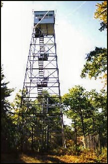
Description
Located on the Oxford State Forest, the original Oxford Fire Tower was a 68’ iron tower built in the early 1920s. It was destroyed in the disastrous 1938 hurricane. The current 68’ steel tower with 10’x10’ wooden cab was built in 1939.
As of March 2019, the tower is fenced and posted with No Trespassing signs.
Map
Change Basemap