Westborough Fire Tower
US 1017, MA 46
2014 Tom Ashton photo
Lookout Details
| Registry Numbers | US 1017, MA 46 (view other lookouts in United States, Massachusetts) |
| Date Registered | September 3, 2014 |
| Nominated by | Henry Isenberg |
| Location |
Fay Mountain Worcester County, Massachusetts |
| Coordinates |
N 42° 14.383' W 071° 37.666' (view using Google Maps) N 42° 14' 23" W 071° 37' 40" N 42.239722° W 071.627770° |
| Elevation | 707 ft (215 m) |
Description
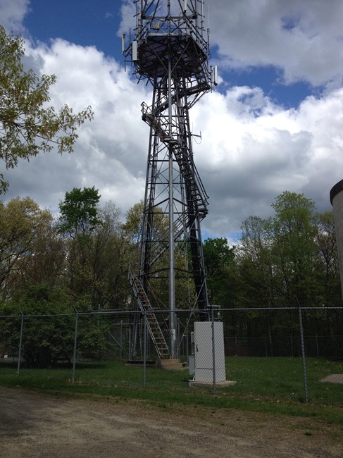
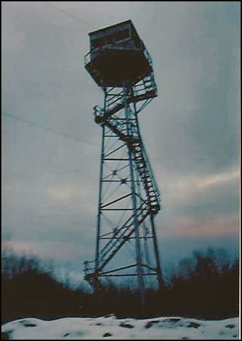
Located on top of Fay Mountain, a fire tower has been on this site since 1911 when a 38-foot tower with an 8'-by-8' cab was built. It was replaced in 1915 with a new 68-foot tower sporting a 10'-by-10' cab; the old tower was moved to Chester. This tower was destroyed in the great hurricane of 1938 and replaced by a temporary tower. In 1939, a new 68-foot steel tower was built.
The 1939 tower was eventually replaced when the US Army which built a radar tower on the site. After the radar was discontinued in 1970, Massachusetts built a new cab on top of the three-legged radar tower. Use of this site was discontinued in 1982, at which time the tower was transferred to the city of Westboro and eventually to a private landowner. Today, the fire cab has been replaced by a platform used to mount communication antennas.
This was one of the only two three-legged towers built in Massachusetts.
Map
Change Basemap
Photos
Henry Isenberg photo
Visit Reports
September 7, 2014: Tom Ashton
Condition |
|
| Needs paint? | No Response |
| Shutters OK? | No Response |
| Condition of wood OK? | Yes |
| Stairs OK? | Yes |
| Glass intact? | No Response |
| Good condition? | Yes |
| Comments: | No longer owned by the Commonwealth of Massachusetts, this tower is now located on private property accessible by private ROW. Now used as a high ground antenna site. |
Electronics and Enroachments |
|
| Are electronic sites enroaching on tower? | Yes |
Access and Signs |
|
| NHLR sign posted? | No |
| Directions to tower signed? | No |
Staffing |
|
| Staffed? | No |
Opportunities for Volunteer Support |
|
| Volunteers staffing opportunities? | No Response |
| Volunteer maintenance opportunities? | No Response |