Union Peak Lookout
US 476, MT 37
Lookout Details
| Registry Numbers | US 476, MT 37 (view other lookouts in United States, Montana) |
| Date Registered | March 31, 2003 |
| Location | Granite County, Montana |
| Coordinates |
N 46° 48.461' W 113° 23.906' (view using Google Maps) N 46° 48' 28" W 113° 23' 54" N 46.807680° W 113.398430° |
| Elevation | 6,723 ft (2,049 m) |
| Administered by | Montana DNRC, Forestry Division |
| Cooperators | Montana DNRC, Forestry Division |
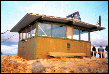
Description
The Blackfoot Forest Protective established Union Peak Lookout as a crow’s nest tree platform in 1930. Five years later it was replaced by a 70’ steel tower. In 1963 the present 15’x15’ groundhouse with slightly sloped gable-flattop roof., a unique BFP design, was constructed and remains in service. In 1973 the Montana Dept. of Natural Resources and Conservation assumed responsibility for the lookout.
Map
Change Basemap