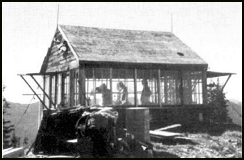
Wam Mountain Lookout
US 350, MT 32
Lookout Details
| Registry Numbers | US 350, MT 32 (view other lookouts in United States, Montana) |
| Date Registered | May 12, 2000 |
| Location |
Kootenai National Forest Lincoln County, Montana |
| Coordinates |
N 48° 57.296' W 114° 48.631' (view using Google Maps) N 48° 57' 18" W 114° 48' 38" N 48.954925° W 114.810522° |
| Elevation | 7,121 ft (2,170 m) |
| Administered by | U.S. Forest Service |
| Cooperators | Fortine Ranger District |
| Available for Rental | Yes, learn more |
Description
One of the last gable roof L-4s, Wam Mountain Lookout was constructed in 1931 by the Forest Service atop a 7,121' peak in the Whitefish Range in Montana. Last used for fire detection in the 1950s, the lookout escaped destruction probably because of its remote location.
Map
Change Basemap