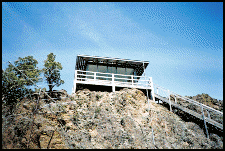
Rancheria Rock Lookout
US 470, OR 67
Lookout Details
| Registry Numbers | US 470, OR 67 (view other lookouts in United States, Oregon) |
| Date Registered | March 1, 2003 |
| Location | Wheeler County, Oregon |
| Coordinates |
N 44° 53.913' W 120° 08.277' (view using Google Maps) N 44° 53' 55" W 120° 08' 17" N 44.898550° W 120.137950° |
| Elevation | 4,809 ft (1,466 m) |
| Built | 1950 |
| Administered by | Oregon Department of Forestry |
| Cooperators | Oregon Department of Forestry |
Description
One of the most endangered sites in Oregon, Rancheria Rock Lookout is worth saving. The Oregon Department of Forestry model 14' x 14' cab was built in the 1950s, replacing an earlier structure dating from the 1930s. Located on BLM land, it is no longer in active service. There is interest in neighbors and the community in restoring it in association with a nearby state park. The Oregon Chapter of the FFLA is handling communications on the project.
Map
Change Basemap