Burns (Bell) Lookout Tower
US 1778, TN 74
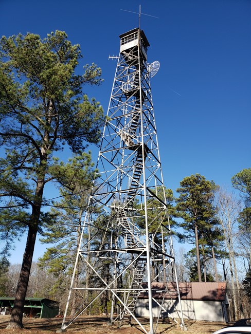
Photo courtesy of Jerry Lutes
Lookout Details
| Registry Numbers | US 1778, TN 74 (view other lookouts in United States, Tennessee) |
| Date Registered | December 31, 2023 |
| Nominated by | Jerry Lutes |
| Location |
Montgomery Bell State Park Dickson County, Tennessee |
| Coordinates |
N 36° 03.866' W 087° 16.966' (view using Google Maps) N 36° 03' 52" W 087° 16' 58" N 36.064440° W 087.282765° |
| Elevation | 868 ft (265 m) |
| Built | early 1950s |
| Administered by | Tennessee Division of Forestry |
Description
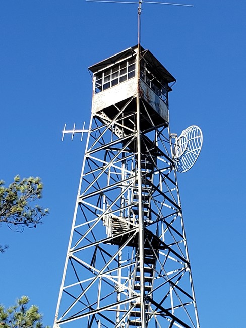
This steel International Derrick MC-39 tower was built in the early 1950s. It is approximately 80 feet tall with steel stair treads. It was erected by the Tennessee Division of Forestry for fire detection in Dickinson County and surrounding areas.
The tower is situated within the 5,000-acre Montgomery Bell State Park. The park contains a 1,086-acre natural area with two tracts of high-quality oak/hickory forest.
Map
Change Basemap
Photos
February 2023 photo
Visit Reports
February 13, 2023: Jerry Lutes
Condition |
|
| Needs paint? | Yes |
| Shutters OK? | Not Applicable |
| Condition of wood OK? | No |
| Stairs OK? | Yes |
| Glass intact? | No |
| Good condition? | Yes |
| Comments: | International Derrick Tower. Overall in decent shape. Has been repainted sometime in the past, but could be repainted again. No signs of rust present though. Tower has metal treads, and wooden landings - diagonal step pattern (MC-39 type). Several windows were missing from cab. Talked to the District Forester - Brian Hughett. He state there was no money in the budget for fire tower maintenance. The tower has a sign that says the tower can be climbed at users risk, but he advised against it, due to deterioration of the wood landings. Did not access the cab for condition. This tower is located at the District Headquarters for the Highland Rim district. Currently, the site is closed for logging operations (due to Tornado damage). |
Electronics and Enroachments |
|
| Are electronic sites enroaching on tower? | Yes |
| Comments: | Several antennas are located on the tower, presumably for communications with the district headquarters. |
| Other enroachments? | Site is the District Headquarters for the Highland Rim District. Headquarters buildings, several maintenance sheds and buildings on site. Small log structure on site, may have been original watch persons' residence. |
Access and Signs |
|
| NHLR sign posted? | No |
| Directions to tower signed? | No |
| Comments? | Site is currently closed due to storm damage/tornado cleanup - Logging operations. Site is normally open during normal business hours during the week, but closed on weekends. Access is on gravel road, turning off of Highway 47. Steel Entrance gate, at turn off from Highway. Road goes through one lane railroad underpass immediately past gate. Road continues uphill for approximately 1/2 mile to tower/district headquarters. |
Staffing |
|
| Staffed? |
No
According to district forester Brian Hughett, tower is not staffed anymore. Last used for fire detection in Mid 1970's.
|
Opportunities for Volunteer Support |
|
| Volunteers staffing opportunities? | Unsure |
| Volunteer maintenance opportunities? | Yes |